Google dot org blog - News from Googles Philanthropic Arm

Using search patterns to track dengue fever

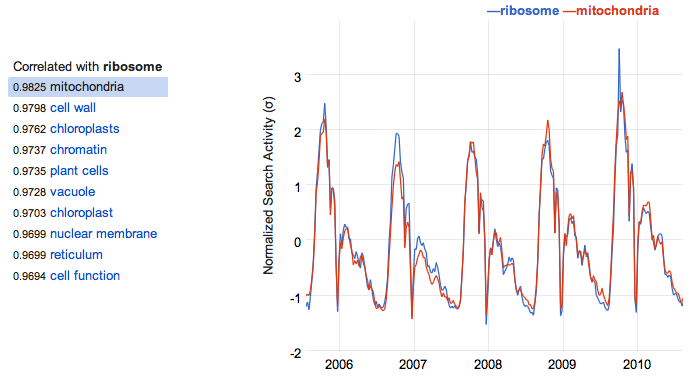
What does baseball have in common with gazebos? We’re not sure, except that people search on Google for both terms in similar patterns. Last week we introduced Google Correlate, an experimental tool enabling researchers to model real-world behavior using search trends. We’ve heard from many researchers who want to mine this data for new discoveries about economics and public health—much like we designed Google Flu Trends to give an early warning about flu outbreaks. We hope they’re able to make useful discoveries with Google Correlate.

While building Google Correlate, we used it to create an early warning system for another important disease. Google Dengue Trends in Bolivia, Brazil, India, Indonesia and Singapore provides an additional surveillance tool for a disease that affects about 100 million people each year. Dengue is a virus spread through mosquito bites that creates symptoms including high fever, severe headache and pain, rash and mild bleeding. There is no vaccine or treatment, so public health efforts are largely focused on helping people take steps to prevent being infected with the disease.

Singapore has an impressively timely surveillance system for dengue, but in many countries it can take weeks or months for dengue case data to be collected, analyzed and made available. During the dengue outbreak at last year’s Commonwealth Games, we discussed the need for timely dengue information. With help from Professor John Brownstein and Emily Chan from HealthMap, a program at Children’s Hospital Boston and Harvard Medical School, we were able to create our system. Using the dengue case count data provided by Ministries of Health and the World Health Organization, we’re able to build a model that offers near real-time estimates of dengue activity based on the popularity of certain search terms. Google Dengue Trends is automatically updated every day, thereby providing an early indicator of dengue activity.

The methodology for this system is the same as that for Google Flu Trends and is outlined in a newly published article in PLoS Neglected Tropical Diseases.

We hope the early warning provided by Google Dengue Trends helps health officials and the public prepare for potential dengue outbreaks. For those who live in places where dengue is present, remember to follow the advice of health officials to prevent infection by wearing mosquito repellent and emptying any containers that lure mosquito larvae by gathering standing water.

Permalink | Links to this post |

Mining patterns in search data with Google Correlate

(Cross-posted from The Official Google Blog)

It all started with the flu. In 2008, we found that the activity of certain search terms are good indicators of actual flu activity. Based on this finding, we launched Google Flu Trends to provide timely estimates of flu activity in 28 countries. Since then, we’ve seen a number of other researchers—including our very own—use search activity data to estimate other real world activities.

However, tools that provide access to search data, such as Google Trends or Google Insights for Search, weren’t designed with this type of research in mind. Those systems allow you to enter a search term and see the trend; but researchers told us they want to enter the trend of some real world activity and see which search terms best match that trend. In other words, they wanted a system that was like Google Trends but in reverse.

This is now possible with Google Correlate, which we’re launching today on Google Labs. Using Correlate, you can upload your own data series and see a list of search terms whose popularity best corresponds with that real world trend. In the example below, we uploaded official flu activity data from the U.S. CDC over the last several years and found that people search for terms like [cold or flu] in a similar pattern to actual flu rates. Finding out these correlated terms is how we built Google Flu Trends:


You can also enter a search term such as [ribosome] and find other terms whose activity corresponds well over time with the one you’re interested in:


It turns out cell biology isn’t all too popular in the summer time (sorry biologists!). What’s interesting is that the ups and downs of web search activity for cell biology terms is unique enough that searching on Correlate for [ribosome] brings up searches for other biology terms, such as [mitochondria]. Of course, correlation isn’t the same thing as causation, so we can’t explain why two terms follow the same pattern. But my guess in this case is that both terms are popular when schools teach these concepts.


Search activity is an incredible source of data that may lead to advances in economics, health and other fields; but we need to handle that data with privacy controls in mind. With this system, we don’t care what any one person is searching for. In fact, we rely on millions of anonymized search queries issued to Google over time, and the patterns we observe in the data are only meaningful across large populations.

We encourage you to read our white paper describing the methodology behind Google Correlate. Or for lighter reading, check out our comic! We’ve enjoyed uploading different data sets to see fascinating and sometimes perplexing correlations. Plug in your data and let us know what you find.

Permalink | Links to this post |

Hacking for humanity in Silicon Valley and around the globe

(Cross-posted from The Official Google Blog)


Two years ago representatives from Google, Microsoft, Yahoo!, Hewlett-Packard, NASA and the World Bank came together to form the Random Hacks of Kindness (RHoK) program. The idea was simple: technology can and should be used for good. RHoK brings together subject matter experts, volunteer software developers and designers to create open source and technology agnostic software solutions that address challenges facing humanity. On June 4-5, 2011 we’ll hold the third Random Hacks of Kindness global event at five U.S. locations and 13 international sites, giving local developer communities the opportunity to collaborate on problems in person.


The RHoK community has already developed some applications focused on crisis response such as I’mOK, a mobile messaging application for disaster response that was used on the ground in Haiti and Chile; and CHASM, a visual tool to map landslide risk currently being piloted by the World Bank in landslide affected areas in the Caribbean. Person Finder, a tool created by Google’s crisis response team to help people find friends and loved ones after a natural disaster, was also refined at RHoK events and effectively deployed in Haiti, Chile and Japan.

We’re inviting all developers, designers and anyone else who wants to help “hack for humanity,” to attend one of the local events on June 4-5. There, you’ll meet other open source developers, work with experts in disaster and climate issues and contribute code to exciting projects that make a difference. If you’re in Northern California, come join us at the Silicon Valley RHoK event at Google headquarters.

And if you’re part of an organization that works in the fields of crisis response or climate change, you can submit a problem definition online, so that developers and volunteers can work on developing technology to address the challenge.

Visit http://www.rhok.org/ for more information and to sign up for your local event, and get set to put your hacking skills to good use.


Permalink | Links to this post |

Our testimony on how technology can aid crisis response

(Cross-posted from the Google Public Policy Blog)

This morning Shona Brown, Senior Vice President of Google.org, was on Capitol Hill to testify before the Senate Homeland Security Committee on the use of technology in coordinating disaster relief efforts.

Google plays a modest role in crisis response compared to relief organizations and agencies, but we have found that the Internet can help users and relief workers quickly find the information they need during emergencies. For example, Google Person Finder – which helps loved ones reconnect during emergencies – managed more than 600,000 records following the earthquake in Japan, and there were more than 36 million page views within the first 48 hours alone.

During her testimony, Shona outlined three reasons how simple, standard and open Internet-based technologies are critical tools for emergency responders and affected populations: the Internet often remains available when other networks fail, people often turn to Internet services during emergencies, and the Internet scales and promotes openness.

Posted by Pablo Chavez, Director of Public Policy

Permalink | Links to this post |

Using the power of mapping to support South Sudan

(Cross-posted from The Official Google Blog)

Last Thursday, the Google Map Maker team, along with the World Bank and UNITAR/UNOSAT, held a unique event at the World Bank Headquarters in Washington, D.C., and a satellite event in Nairobi at the same time. More than 70 members of the Sudanese diaspora, along with regional experts from the World Bank, Sudan Institute, Voices for Sudan, The Enough Project and other organizations gathered together to map what is expected to become the world’s newest country later this year: the Republic of South Sudan. UN Secretary-General Ban Ki-moon has asked the international community “to assist all Sudanese towards greater stability and development” during and beyond this period of transition.

South Sudan is a large but under-mapped region, and there are very few high-quality maps that display essential features like roads, hospitals and schools. Up-to-date maps are particularly important to humanitarian aid groups, as they help responders target their efforts and mobilize their resources of equipment, personnel and supplies. More generally, maps are an important foundation for the development of the infrastructure and economy of the country and region.

The Map Maker community—a wide-ranging group of volunteers that help build more comprehensive maps of the world using our online mapping tool, Google Map Maker—has been contributing to the mapping effort for Sudan since the referendum on January 9. To aid their work, we’ve published updated satellite imagery of the region, covering 125,000 square kilometers and 40 percent of the U.N.’s priority areas, to Google Earth and Maps.

The goal of last week’s event was to engage and train members of the Sudanese diaspora in the United States, and others who have lived and worked in the region, to use Google Map Maker so they could contribute their local knowledge of the region to the ongoing mapping effort, particularly in the area of social infrastructure. Our hope is that this event and others like it will help build a self-sufficient mapping community that will contribute their local expertise and remain engaged in Sudan over time.

We were inspired by the group’s enthusiasm. One attendee told us: “I used to live in this small village that before today did not exist on any maps that I know of...a place unknown to the world. Now I can show to my kids, my friends, my community, where I used to live and better tell the story of my people.”


The group worked together to make several hundred edits to the map of Sudan in four hours. As those edits are approved, they’ll appear live in Google Maps, available for all the world to see. But this wasn’t just a one-day undertaking—attendees will now return to their home communities armed with new tools and ready to teach their friends and family how to join the effort. We look forward to seeing the Southern Sudanese mapping community grow and flourish.

Permalink | Links to this post |

Announcing the Google Earth Outreach Developer Grants Program

Over the years, the Google Earth Outreach team has seen hundreds of maps that nonprofits are using to change the world for the better. We’ve also talked to just as many nonprofits who have a great idea for a map they want to create, but don’t have people on their team with enough technical skills to create it.

Today, we’re excited to announce the Google Earth Outreach Developer Grants program, supporting selected projects from eligible nonprofit organizations that are using Google’s mapping technologies in novel, innovative ways to make the world a better place.

Through this program, non-profit organizations from all over the world will have an opportunity to receive up to $20,000 that will help turn their mapping ideas to support their causes into a reality. Numerous nonprofits have already used Google Earth to raise awareness about an issue or cause that demonstrate innovation and creativity. The US Holocaust Memorial Museum and partners created the Crisis in Darfur Google Earth layer, which utilized Google Earth’s high-resolution satellite imagery to document the burning of villages, destruction of communities and livelihoods as a result of the genocide in Sudan. The presentation of refugee stories and testimonials in a map visualization brought 26 times the usual number of visitors to the USHMM’s “How Can I Help?” section of the website.

Charity:Water uses the Google Maps API to show donors precisely where the money they contributed was allocated. After donating, donors receive geographic coordinates to view the location of a well to which they’ve contributed, and they can also view pictures of people accessing clean drinking water as a result of their contribution.

Charity:Water connects donors to well sites all over the globe.

Applications to the Google Earth Outreach Developer Grants program will be accepted until May 26, 2011. More details of the program, project requirements and eligibility can be found on the Google Earth Outreach Developer Grants page. Apply today!

Permalink | Links to this post |