Google dot org blog - News from Googles Philanthropic Arm

New imagery of Japan after the earthquake

(Cross-posted from the Lat Long Blog)

It’s now the third week after the devastating 9.0-magnitude earthquake that struck northeastern Japan. Aid organizations have been hard at work and cities are starting to show signs of recovery, but the damage is beyond imagination and there are still thousands of people at shelters grappling with daily challenges. As a native of Sendai city, I’m still speechless seeing the destruction and damage that has been done to the places I love and care about.

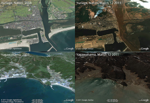
We’ve been looking for ways we can assist in the relief efforts using Google’s map-related tools. A few days after the quake, we published updated satellite imagery of northeast Japan in Google Maps and Google Earth, which illustrated the massive scale of devastation in the affected areas.

Today, we’ve published imagery of the Sendai region at even higher resolution, which we collected on Sunday and Monday. The new Sendai imagery, along with satellite imagery from throughout the area, is now live in the base imagery layer of Google Earth and will soon be visible in Google Maps. We hope to continue collecting updated images and publishing them as soon as they are ready.

We hope our effort to deliver up-to-date imagery provides the relief organizations and volunteers working around the clock with the data they need to better understand the current conditions on the ground. We also hope these tools help our millions of users—both those in Japan and those closely watching and sending their support from all over the globe—to find useful information about the affected areas.

A riverside neighborhood in Sendai from our newly released imagery

Permalink | Links to this post |

Best practices for building Internet capacity in Liberia

Over the past year, several Googlers have made trips to Liberia, one of the world’s poorest countries with a per capita GDP of $500. As shown in the figure below, Liberia has one of the lowest volumes of Internet traffic per capita in the world, and ranks in the bottom quintile within Africa.


Historically constrained by slow and expensive satellite connections for Internet connectivity, the country expects to connect to the ACE submarine cable in 2013. This international connectivity will enable the deployment of low-cost infrastructure and accelerate the adoption of inexpensive Internet-enabled devices. As such, Liberia has an excellent opportunity to harness the Internet for economic and human development gains over the next few years.

At Google.org, we are contributing ideas for Liberia’s efforts to build Internet capacity, outlined in a white paper, “Best Practices for Liberia’s Internet Ecosystem.” We outline principles for establishing a strong Internet foundation in Liberia. Suggestions include piggybacking on non-telecom infrastructure investments, creating an Internet exchange point, and opening spectrum in WiMax, WiFi and TV white spaces for ISPs.

In putting this white paper together, we benefited from the diversity of global challenges that Googlers have experienced when working with networks. The paper also taps into the first-hand knowledge of local stakeholders across public, private, and non-profit sectors. In collaboration with the many complementary players in Liberia, we aim to turn technology opportunity into development progress.

Permalink | Links to this post |

More resources for those affected by the Japan earthquake and tsunami

Like the rest of the world, we’ve been transfixed by the images and news coming out of the northeastern part of Japan over the past six days. Our hearts go out to those who have been affected by this devastation and we’re deeply grateful to those who are working to keep us safe. In the meantime, Googlers in Japan and elsewhere around the world have been working around the clock to try and help improve the flow of information. Here are some of the recent developments we’ve been working on:

Centralized information
Our Crisis Response page—now in Japanese, English, Chinese and Korean—organizes all of Google’s efforts, with links to valuable resources such as emergency hotlines, Person Finder, blackout schedules, maps and links to relief organizations receiving donations. Ninety-three percent of mobile users in Japan don’t have top-of-the-line smartphones, so we’ve recently optimized this Crisis Response page to make it more readable for a wider range of devices. You can also access that version by scanning this QR code:

Person Finder
Within the first two hours of the earthquake, we launched Person Finder so people can enter the names of those they’re looking for or have found. You can now also search by entering mobile phone numbers to see if they match any listings. And as with the Crisis Response page, Person Finder has also been optimized for those without smartphones. There are currently more than 250,000 records in the database (including names shared with us by NHK, the national broadcaster in Japan) and we’ve heard several reports of people who have found their loved ones safe.

To help the many people in shelters get word of their whereabouts to loved ones, we’re also asking people in shelters to take photos of the handwritten lists of names of current residents and email them to us. Those photos are automatically uploaded to a public Picasa Web Album. We use scanning technology to help us manually add these names to Person Finder; but it’s a big job that can’t be done automatically by computers alone, so we welcome volunteers with Japanese language skills who want to help out.

Satellite images
We’re also working with our satellite partners GeoEye and DigitalGlobe to provide frequent updates to our imagery of the hardest-hit areas to first responders as well as the general public. You can view this imagery in this Google Earth KML, browse it online through Google Maps or look through our Picasa album of before-and-after images of such places as Minamisanriku and Kesennuma.

Mapping
You can follow developments on the ground by looking at several maps that track changing developments. We’ve mapped rolling blackouts for areas that are affected by power outages. With data given to us by Honda, you can now see which roads have been recently passable on this map or this user-made Google Earth mashup with new satellite imagery. We’re also constantly updating a master map (in Japanese and English) with other data such as epicenter locations and evacuation shelters. And with information from the newspaper Mainichi, we’ve published a partial list of shelters.

Translation
Use Google Translate for Japanese and 56 other languages. You can paste in any text, or enter the address of any web page for automatic translation. We also just released an early experimental version of Google Translate for Android to help non-Japanese speakers in affected areas.

Donations
Visit our Crisis Response resource page to find opportunities to donate. When you donate to Japan relief efforts through Google Checkout, we absorb processing fees—so 100% of your money goes to the organizations. Google has also donated $250,000 to help the people of Japan recover.

To keep up with the latest developments on our efforts in Japan, follow @googlejapan (tweets are mostly in Japanese) or @earthoutreach (for our mapping and imagery efforts) on Twitter.

Permalink | Links to this post |

Post-earthquake imagery of Japan

(Cross-posted from the LatLong Blog)

In response to the devastating earthquake and subsequent tsunami that struck Japan, we’ve worked with our satellite imagery providers to get the latest available data of the areas affected most.

To view this high-resolution imagery, courtesy of our partners at GeoEye, download this KML file and explore it in Google Earth. You can also explore the imagery with Google Maps, or have a look at this Picasa album of before-and-after shots. Here’s a sample:


Before and after the earthquake and tsunami. Above is Yuriage in Natori, below is Yagawahama; both are in Miyagi prefecture. High-resolution version of this photo.

We’re working to provide this data directly to response organizations on the ground to aid their efforts. We hope this new updated satellite imagery is valuable for them as well as everyone else following this situation to help illustrate the extent of the damage.

You can find more information regarding the disaster and resources for those in need at our Crisis Response page in English and Japanese. You can also follow @earthoutreach on Twitter to stay up to date with our mapping and imagery efforts.

Permalink | Links to this post |

Assembling resources following the earthquake in Japan

I was in the middle of writing code when the Google Japan office, on the 26th floor of Roppongi Hills in Tokyo, started shaking slowly. The rocking gradually increased, and I looked out the window to see the surrounding buildings all swaying ominously. Although alerts from the building urged us to evacuate via the emergency stairs, I couldn't help but stay and search for information about the earthquake’s epicenter and scale. Amidst a series of aftershocks rocking our office, a small group of us in Tokyo and several other Google offices started gathering information about the earthquake to create the Crisis Response information page.

As someone who experienced the Kobe earthquake 16 years ago when I was at university, I cannot forget the immediate desire for information. There was no way to find out where people's family and friends were, if transportation would be available to get us home, and most importantly, whether we would be able to find shelter.

This experience helped me remember that during a crisis, information about shelters can become increasingly muddled. Together with our Google Crisis Response team, we decided to organize existing public information from local governments about the concerned areas. Because of the very high volume of web traffic yesterday, this proved difficult to access. Collaborating with the Google Maps engineering team in Tokyo, we rapidly put together a page of information on Google Maps for our Crisis Response page.

And thanks to our colleagues in California and around the globe, within one hour of the earthquake we launched Google Person Finder, a tool to help locate missing people, in Japanese, Chinese and English. We published sites in Japanese and English with maps, news updates, videos, and resources. We also posted tsunami alerts on the Google homepage for appropriate domains to make sure as many people as possible saw the warning. And in addition to these tools we've made available, we are donating $250,000 to organizations in Japan who are working on relief and recovery efforts.

Our hearts go out to those who have been affected by the tragedy, and we thank the citizens, first responders and organizations working hard to keep everyone safe.

Permalink | Links to this post |

Women get together to map Kenya

Cross-posted from the Google Africa Blog

Many people enjoy using Google Maps to locate and learn about places around the world. Others, however, relish taking a more active role: improving Google Maps by adding and editing roads, parks, businesses, and more through Google Map Maker. In some cases, these citizen mappers take a day to collaboratively focus on a specific area, as more than 60 women did recently in Nairobi, Kenya. Together, they planned a “Ladies Mapping Party,” with the goal of empowering and inspiring a broad array of women to give back to their communities through mapping. From advocates to non-profit leaders, students to computer scientists, environmentalists to editors, these women mapped the places they live and love, know and often visit.

The event began with a short training and demo session during which participants received an overview of Google Map Maker, followed by a competition to spur the groups on to map their communities.


Training and demo session

One of the groups was comprised of three dynamic students from Strathmore University - Betsy, Issene and Yasmin. Within 30 minutes, they had mapped most of the points of interest in their home town, Isiolo, while the broader group of women worked together on Juja, Ongata Rongai and Nyahururu.

This strategy of targeted specific regions in Africa seemed to work well for the attendees. “We decided to map Isiolo because we know the area well, and the area had very few points that were mapped compared to other areas like Nairobi,” noted one of the students, who also joked that the prizes - including Google-branded bags - further encouraged them to map so comprehensively.


Issene, Betsy and Yasmin: contributors at the event

Many of the participants mentioned that they’re eager to continue using Map Maker, citing it as “a new pastime.” But the women took away more than just mapping knowledge, with one of the mappers noting that the group “learned from the others that doing what you love is the key to success.”

Interested in mapping your part of the world? Give Google Map Maker a try.

Posted by Jacqueline Rajuai, GIS Specialist, Google Kenya

Permalink | Links to this post |

Click-to-call emergency information

In November 2010, we began displaying relevant emergency phone numbers at the top of the results page for searches around poison control, suicide and other common emergencies in 14 countries. Today, we are making it even easier for you to quickly reach the help you may need by adding click-to-call capabilities for all of these emergency information search results.

We piggybacked on the way that our mobile ads team enabled click-to-call phone numbers in local ads on mobile devices. This capability enables businesses to make it even easier for customers to reach them when those customers search on Internet-enabled mobile devices. The functionality seemed ideal for the emergency information feature.

Previously, mobile users in one of these countries who conducted searches around poison control, suicide and common emergency numbers received a result showing the relevant emergency phone number.

People on mobile will now get the same result, but the phone number will be a link that allows you to dial the number instantly, just by clicking the link.


Now, the poison control result in Spain is click-to-call on a mobile phone

We hope this addition is a small step that helps connect people with crucial information that they need immediately.

Permalink | Links to this post |

Find electric vehicle charging stations on Google Maps

(Cross-posted from the Google Lat Long blog)

At Google, we’ve been supporting environmentally-friendly cars through initiatives such as RechargeIT, an effort to accelerate the adoption of electric vehicles. As consumers embrace electric vehicles, we’ve also been adding information to Google Maps over the past few months to help users find charging stations. Just search on Google Maps for “ev charging station” plus the appropriate area, for example, “ev charging station near mountain view ca.”


We’d like to continue adding more charging stations to Google Maps, so we’re excited that our friends over at the the U.S. Department of Energy’s National Renewable Energy Laboratory (NREL) are working to make more data available.

NREL has launched the GeoEVSE Forum to help develop a detailed, accurate database of electric vehicle charging stations. We’ll be adding more EV charging locations to Google Maps as their database, and others, are updated. As always, you can use the Report a problem tool to inform us of any corrections.

If you represent an automaker, an electric vehicle charging station manufacturer or installer, an EV consumer group or any other interested party, you can join the GeoEVSE Forum by visiting this site.

We look forward to adding even more information to Google Maps to help you recharge your electric vehicle. Happy green driving!

Posted by Cynthia Yeung, Strategic Partner Development Team

Permalink | Links to this post |

Unleashing energy innovation

The Internet, digital music, smart phones - these are just some of the innovations that have changed the way we live and work. Yet the way we use energy - whether it’s powering our cars or our homes and businesses - hasn’t changed in decades. Our economy needs a cleaner, more efficient way of delivering energy while giving people better tools and information to manage their energy use.

The good news is there’s widespread agreement that transforming the energy sector is a big opportunity to create jobs, foster innovation and grow new industries. At Google, we’ve been working to transform our own energy use. We’ve made our data centers the most efficient in the world, built a fleet of electric cars, invested in renewable energy, and developed online tools like Google PowerMeter.

Of course, government policy plays an important role in driving change towards a cleaner economy and it’s important to get the rules right. There’s a real debate happening now in Washington about how to solve the nation’s energy challenges. We don’t have all the answers, but here are a few important areas that policymakers should consider:

  • Drive investments in energy infrastructure and technology. With the right mix of policies, vast amounts of private capital can be leveraged to develop the next generation of energy infrastructure. That means a smarter, more efficient power grid and more renewable power generation, whether it’s utility-scale or on rooftops. The government should provide clear market signals through measures such as energy efficiency and clean energy standards. And we should deploy a variety of incentives to help take new technologies to full commercial scale.
  • Stimulate R&D to find the next technological breakthroughs. We should support research and development that can lead to the next energy breakthroughs, including innovative programs like the Advanced Research Projects Agency-Energy (ARPA-E), which has spurred four dollars in private sector investment for every taxpayer dollar spent.
  • Remove barriers to innovation and empower energy consumers. Regulatory and market barriers have created huge inefficiencies in the way homes and businesses use energy. Consumers still lack basic information and tools for better managing their energy use. Utility regulation must be brought into the 21st century to promote investments in efficiency and renewables and reductions in peak energy demand. That includes enacting policies that give consumers access to and control over their own energy information.
We’ll be engaging on these issues over the next few months. In the meantime, we invite you to post comments and join the conversation!

Posted by Michael Terrell, Energy Policy Counsel

Permalink | Links to this post |

Getting More People and Information Online in Africa -- including Nelson Mandela’s and Desmond Tutu’s Archives

(Cross-posted from The Google Africa Blog to bring you information on philanthropic efforts across Google)

As one of the most influential leaders of our time, and the face of South Africa’s incredible transition to democracy, Nelson Mandela’s name is almost synonymous with efforts to create meaningful dialogue and promote social justice. It is with huge excitement that today we announce a $1.25 million dollar grant to the Nelson Mandela Foundation Centre of Memory, which will help to preserve and digitize thousands of archival documents, photographs, and audio-visual materials about the life and times of Nelson Mandela.


The online Mandela archive, which will be made available to the global audiences in the future, will be a wealth of information for those wanting to learn about and research the life and legacy of this extraordinary African statesman. The online multimedia archive will include Mr Mandela’s correspondence with family, comrades and friends, prison diaries, and notes he made while leading the negotiations that led to the end of apartheid in South Africa.


A grant of the same size has also been made to the Desmond Tutu Peace Centre in Cape Town, for the documentation and digitisation of Desmond Tutu’s archive, as well as an interactive digital learning centre.

At Google we want to help bring the world’s historical heritage online -- and the Internet offers new ways to preserve and share this information, in Africa and elsewhere. Recent examples of our efforts in this field include our partnership with Yad Vashem, the Jerusalem-based archive of Holocaust materials, and our partnership with some of the world’s most famous art museums, through the Art Project.

We are also delighted to be announcing additional grants, also through the Google Inc. Charitable Giving Fund of Tides Foundation, which will help bring many more people online across South Africa and Africa, so that they can benefit from better access to information. These include grants to the Tertiary Education and Research Network (TENET) of South Africa ($750,000 for continued work to assist South African universities with Internet and information technology services), the Nigeria ICT Forum ($500,000 to support efforts in improving access to Internet infrastructure in tertiary education institutions in Nigeria), and the Network Startup Resource Center (NSRC) at the University of Oregon ($1,250,000 to enable more people in numerous African countries to participate in and contribute to the global Internet).

Permalink | Links to this post |

Post-earthquake images of Christchurch, New Zealand

(Cross-posted from the Google Lat Long Blog)

We’ve been closely following the news about the damage from the magnitude 6.3 earthquake on February 22. We recently published new satellite imagery over the affected area to show an aerial view of the impact. To view this high-resolution imagery, courtesy of our partners at GeoEye, download this KML and explore it in Google Earth. You can also have a look at this Picasa album of before and after shots. Here’s an example of what you’ll see:


Before and after shots of the central business district. The north-south street is Manchester Street.

As a response to this recent catastrophic event, our Crisis Response team also worked quickly to get important information, relevant news and helpful resources to those affected by the disaster and those following developments in New Zealand. We released Person Finder three hours after the earthquake to help people connect with their loved ones. We hope this new updated satellite imagery is valuable for aid workers and the public for illustrating the extent of the damage.

Permalink | Links to this post |